


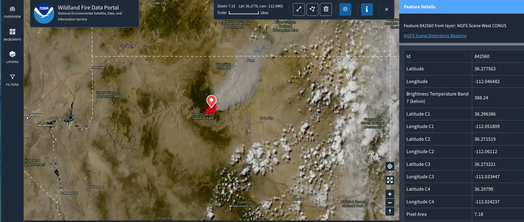
A quarter-acre fire is barely the size of a suburban backyard. Yet in spring 2025, a NOAA satellite spotted one that small. It made the catch in about a minute, from 22,000 miles above the equator. That capability now anchors the NOAA wildfire data portal. It offers a free, public window into a system that is reshaping how the U.S. finds fires early. First responders, insurers, journalists, and land managers all track how agencies actually use open government data. This ranks among the most consequential environmental databases to launch in years. Yet most people have never heard of it.
NOAA’s National Environmental Satellite, Data, and Information Service launched the platform in January 2026. Officially, it is the NESDIS Wildland Fire Data Portal. It opens the experimental products of the Next Generation Fire System to anyone with a browser. Professional firefighters had already leaned on that same feed for a year. Below: how it works, who relies on it, where it breaks new ground, and where its limits lie.
What the NOAA Wildfire Data Portal Actually Is
At its core, the portal is a public front end for the Next Generation Fire System (NGFS). NOAA Satellites and CIMSS — NOAA’s cooperative institute at the University of Wisconsin–Madison — built the system together. It continuously analyzes imagery from the Advanced Baseline Imager aboard the GOES East and GOES West satellites. Its algorithms flag heat anomalies, or potential fire ignitions, even when clouds or smoke partly hide the ground.
Those satellites hold a fixed position over the Western Hemisphere. As a result, they scan a multi-state region every minute. They also refresh a full image of the contiguous U.S. about every five minutes. That cadence is the whole point. Program manager Mike Pavolonis sums it up. NGFS “can provide alerts in as little as one minute” after a fire’s heat reaches the satellite.
The portal organizes itself around a few practical entry points:
- An interactive map that shows near real-time detections as points and terrain-corrected pixel shapes.
- Active Fire Data feeds, documented data services, and an API for programmatic access and event alerts.
- Supporting layers: fire-optimized GOES imagery, boundaries, NWS fire-weather products, and incident data from the National Interagency Fire Center.
I spent time inside the live map, and one thing stands out. It is integrative and easy to use. Most tools force you to stitch together separate satellite feeds and incident reports. This one layers detections, imagery, and incident context in a single view. You can zoom from the national picture down to a local scale without losing your bearings. For a government tool still wearing a “beta” label, that usability is not a given.
Why the NOAA Wildfire Data Portal Matters
The stakes are hard to overstate. NESDIS cites figures from the U.S. Department of the Interior’s Office of Policy Analysis: wildfires cost the United States roughly $424 billion a year. That total covers firefighting, evacuations, health impacts, property loss, agricultural damage, and recovery. In that context, minutes matter. So does who gets the information.
The clearest proof point so far came from a Great Plains wildfire outbreak in Oklahoma. State officials reported that GOES satellites provided the initial detection on 19 separate fires. Preliminary modeling suggested that fast response likely saved more than $850 million in structures and property. NOAA frames it bluntly. The outbreak’s prevented damage ran about 250 times the system’s build cost, which stayed under $3 million. The feed also tracked the large New Jersey Pine Barrens fire. It captured the 2025 Dragon Bravo fire near the Grand Canyon’s North Rim too.
The portal also fits into a wider ecosystem of open environmental data. It complements retrospective resources like NOAA’s Climate Data Online and the cost-focused Billion-Dollar Disasters Database. It pairs naturally with planning tools such as the Colorado Forest Tracker and various wildfire mitigation plans databases. Detection tells you where a fire burns now. Those other datasets explain why it started and what it will cost.
Who Uses It — and What Problem It Solves
The main users are not curious hobbyists. They make time-critical decisions. The NGFS feed went live in February 2025. Within months, roughly 90% of the National Weather Service’s 122 Weather Forecast Offices subscribed. Offices in California, Oregon, New Mexico, Texas, Oklahoma, Nebraska, and North Carolina put it to work within the year. The California Office of Emergency Services pipes NGFS detections into its statewide initial-attack viewer.
The problem it solves is simple: the gap between ignition and detection. Traditional fire reporting waits for someone to notice smoke — a lookout, a hiker, a 911 call. NGFS instead puts a machine on watch, continuously, from orbit. That shift matters most for remote ignitions in the first minutes, when an initial attack has the best odds. For forecasters, planners, and land managers, it means earlier dispatch and smarter deployment of crews and aircraft.
How It Differs From Other Fire Databases
The wildfire-data landscape already has options. NASA’s FIRMS draws on polar-orbiting sensors like VIIRS and MODIS. Crowd-sourced and incident tools such as InciWeb and state viewers add more. The NOAA wildfire data portal stands apart in one decisive way: temporal resolution.
Polar-orbiting satellites deliver sharper detail, but they pass over a given spot only a few times a day. Geostationary satellites trade some spatial resolution for near-continuous monitoring — a fresh look every one to five minutes. NGFS also runs on an event-based data model. Rather than dumping isolated hot-spot pixels, it identifies, tracks, and combines fire events with supporting layers. It also takes a sensor-agnostic approach, so it can fold in more satellites over time. That “track the fire, not just the pixel” design makes it operationally useful, not merely interesting.
Limitations, Data Quality, and Open Questions
A credible look at any database has to name its weak spots. This one has several worth understanding.
It is still experimental. NOAA labels the portal a beta site and its products experimental. It expects full operational status only later in 2026. Until then, treat the feed as decision support, not gospel. Expect the interface and data services to keep changing.
Geostationary detection has physical limits. The GOES imager’s fire-detection resolution is coarse next to polar-orbiting sensors. Very small or short-lived fires can slip through. The system also flags a fire’s existence more reliably than it sizes a tiny one. Viewing angle degrades toward high latitudes, so places like Alaska get far weaker coverage than the contiguous U.S.
False positives are a real risk. Industrial heat, gas flares, or strong solar reflection can all trip a heat-anomaly detector. NGFS applies atmospheric correction and terrain-corrected geolocation to cut the noise. Still, no automated detector is perfect. That is exactly why the system complements human forecasters and ground truth rather than replacing them.
Continuity depends on funding and program status. These experimental products live on the NESDIS Common Cloud Framework, so their long-term stability tracks NOAA’s roadmap. That is a governance question more than a technical one. It still matters for anyone building workflows on the feed.
On privacy, the concerns stay minimal. This is thermal satellite data about the landscape, not personal information. The more interesting angle is transparency. NOAA publishes the same detections its firefighting agencies use. That move extends public accountability into a domain that once sat behind operational walls. That civic value echoes local tools like the LA Environmental Health Data Dashboard. It also fits the broader ESG databases landscape, where public access is the whole point.
Where the NOAA Wildfire Data Portal Is Headed
NESDIS frames the Wildland Fire Data Portal as the first in a planned series of cloud-based public portals. It follows NOAA’s earlier Space Weather Portal. If that vision holds, the fire portal should outgrow beta and add more sensors. It could become a standard reference layer for emergency management nationwide.
Here is the honest assessment. The NOAA wildfire data portal is a genuinely useful, refreshingly usable public resource. It turns a proven professional tool into something anyone can open. Just read it for what it is. It is an early-warning detection feed with real physical limits — not a full record of every fire on the ground.
Sources
- NOAA NESDIS — NOAA Launches Wildfire Data Portal, Expanding Public Access to Satellite Fire Information: nesdis.noaa.gov
- NESDIS Wildland Fire Data Portal (live site and map): fire.data.nesdis.noaa.gov and /map/
- NOAA — NOAA Unveils Powerful Convergence of AI and Science With Revolutionary Next-Generation Fire System: noaa.gov
- GOES-R Program — Advanced Baseline Imager (ABI): goes-r.gov
- National Interagency Fire Center: nifc.gov
- NOAA NCEI — Space Weather Portal: ncei.noaa.gov
This article was created with AI assistance and reviewed by a human editor.

