


For decades, if you wanted to buy a vacant lot from the City of Syracuse, you had to know someone, make a phone call, and navigate a bureaucratic maze that most ordinary residents never got through. That changed in November 2025, when Mayor Ben Walsh launched the Syracuse Vacant Lots Database — an interactive, publicly accessible map of every city-owned vacant parcel available for purchase. The tool is deceptively simple. But its implications for urban redevelopment, neighborhood equity, and government transparency run much deeper than a map widget suggests.
The Problem This Database Is Actually Solving
Syracuse has one of the highest rates of property vacancy of any mid-sized American city. A 2012 city inventory documented 1,648 vacant buildings, with nearly 14 percent of structures sitting empty in neighborhoods like Near Westside and Southwest Syracuse. That number has improved over the years, but the underlying issue — what to do with land the city now owns — has never been fully resolved.
When a property owner stops paying taxes and the city forecloses, that parcel often ends up in municipal limbo. The city holds it. Grass grows. Neighbors complain. Developers with connections get tips. Local residents who actually want to expand their backyard, build a community garden, or develop a small project have no idea the lot is even available.
That information asymmetry is exactly what the Syracuse Vacant Lots Database targets. According to the city’s official press release, prior to the tool’s launch, community members had to contact the city directly and work through multiple steps before learning what was even on offer. Now that inventory is public, searchable, and visual.
What the Syracuse Vacant Lots Database Contains — and How to Use It
The database lives at syr.gov/city-owned-property and is powered by an ArcGIS Experience Builder interface. The full-screen map version is the most useful entry point for serious users.
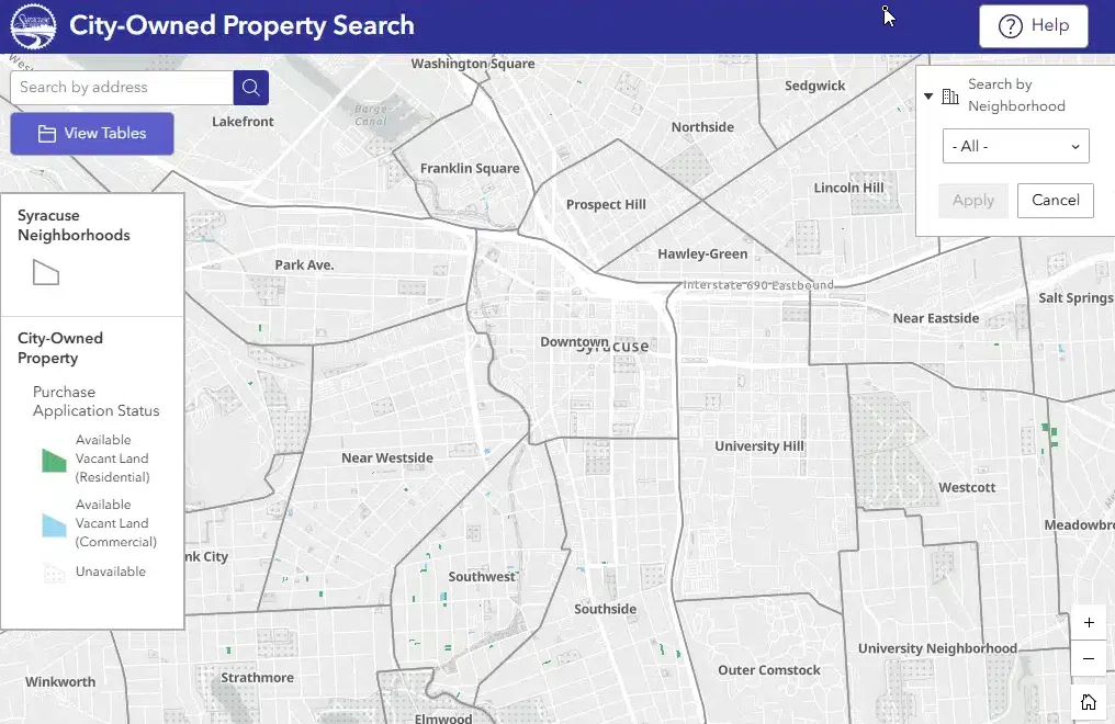
The interface is intuitive. You zoom into any area of the city, and color-coded markers appear — green for residential vacant land, blue for commercial. Click a parcel and a pop-up displays the core property information:
- Property Identifier (SBL) — the standardized section-block-lot number used in New York State property records
- Property Classification — indicating how the city categorizes the land
- Zoning Designation — critical for anyone assessing development potential
- Lot size in acres
Beyond the visual map, there is a Search by Neighborhood function — genuinely useful for residents focused on a specific area rather than an address. The built-in View Tables function unlocks a deeper analytical layer entirely. Switch to table view and you get a structured dataset with significantly more fields:
- Property number and Property ID
- Tax ID
- Street address and ZIP code
- Land use code and land use category
- Owner and owner address
- Assessed land valuation and total assessed value
- Neighborhood designation
That combination of map-based browsing and tabular analytics puts this tool several steps ahead of the typical municipal PDF list or static spreadsheet most cities still rely on.
Who Is This Database For?
The short answer: more people than most municipal property tools serve. Real estate professionals are obvious users — they can quickly scan available city-owned inventory across neighborhoods, check zoning, and assess valuation data before committing to a site visit. But the design also works for non-professionals.
A homeowner on the South Side looking to purchase the adjacent vacant lot and expand their yard can find it, confirm it’s available, and start the application directly from the same interface. A church group exploring a community garden site can filter by neighborhood and see what’s realistically accessible. A small developer scouting an infill opportunity in the Near Westside can cross-reference zoning with assessed land values before calling anyone.
This matters in a city like Syracuse, where past redevelopment efforts have drawn criticism for favoring well-connected developers over local residents. By making the inventory public and searchable, the city at least removes one structural barrier: the knowledge gap.
The Application Process Behind the Database
The map is the front door. The actual purchase process involves more steps — and it’s worth understanding the full picture before getting excited about a $500 lot.
Applications require a detailed development plan, site drawings, and documentation of financing sources. The city assesses proposals on community benefit, not just price. Once staff review is complete, approved applications go to the Syracuse Common Council for a vote. The timeline from submission to decision runs approximately eight weeks.
Pricing follows a tiered structure:
- Rear lots: $0.50 per square foot (minimum $500)
- Small lots (under 30 feet frontage or under 2,000 sq ft): $1.25 per square foot (minimum $500)
- Large lots: Appraised value
- Structures: Appraised value (with possible exceptions under state law)
There is also a non-refundable $500 application deposit, refunded only if the city or Common Council rejects the proposal. Credit card fees apply to online payments. None of this is prohibitive for a serious buyer, but it does mean the database is a research tool, not a checkout cart.
How the Syracuse Vacant Lots Database Compares to Other Municipal Tools
If you browse real estate databases used across American cities, the Syracuse tool stands out for a few reasons — and falls short in others.
On the positive side, the ArcGIS-based interface is far more capable than a static spreadsheet. The neighborhood search function adds accessibility. The table view with assessed valuations gives users real analytical depth. And the integration between the discovery tool and the application portal removes friction from the process.
Where it lags behind more mature platforms: there is no download function for the full dataset visible in the public-facing interface. Data researchers and urban planners accustomed to pulling a CSV export and running their own analysis will need to access the city’s Open Data Portal, which does maintain a broader vacant properties dataset updated regularly. The two resources complement each other but are not fully integrated from a user experience standpoint.
Comparisons with the Greater Syracuse Land Bank’s property search are also instructive. The Land Bank — created jointly by the city and Onondaga County in 2012 — handles tax-delinquent properties going through foreclosure, while the city’s database covers municipally owned land already in city hands. The two inventories overlap in purpose but serve different pipelines. Users serious about acquiring property in Syracuse should check both.
What the Syracuse Vacant Land Database Reveals — and What It Hides
There is a legitimate civic good here that deserves recognition. Making the city’s land inventory public and searchable reduces the conditions under which informal connections and insider knowledge determine who gets access to public assets. That has been a real problem in Syracuse.
But transparency has layers. The database shows what’s available and at what assessed value. It does not show how long parcels have been sitting in city inventory, the history of previous applications or rejections on a given parcel, or why certain properties remain unsold despite apparent demand. For a researcher or journalist trying to understand patterns in how the city disposes of land, those gaps matter.
The assessment data shown in the table view also warrants a note: assessed values in New York State reflect municipal assessments, not market values, and the relationship between the two varies considerably. A lot assessed at $3,000 might be worth significantly more or less depending on neighborhood dynamics, environmental conditions, and infrastructure status. Users should treat assessed values as a starting reference, not a transaction price.
Environmental and Community Context
Vacant lots in Syracuse are not just real estate opportunities — they carry environmental histories. The Atlantic States Legal Foundation has documented extensive work repurposing city-owned vacant lots for green infrastructure, particularly in the combined sewer service area where stormwater runoff is a chronic problem. Some parcels have been converted to rain gardens and bioswales under the Onondaga County Save The Rain program. Others carry soil contamination from prior industrial or residential use.
The city’s database does not flag environmental encumbrances. A parcel may show up as available for $500 per square foot and turn out to carry remediation obligations that make development economically impractical. This is not a criticism unique to Syracuse — most municipal land databases don’t surface environmental data at the parcel level — but it is information a serious buyer needs before applying.
What This Means for Syracuse’s Broader Redevelopment Strategy
Mayor Walsh framed the launch explicitly as part of a commitment to open data and public access. The city’s announcement positioned the tool as reducing friction between residents and available public assets — a meaningful shift in a city where community organizations have long pushed for more transparency in how land is handled.
Syracuse has made measurable progress on vacancy, with the number of vacant properties declining after years of sustained effort through programs like the Vacant Property Task Force and Blight Busting. But returning city-owned land to productive private use remains a core part of that strategy. Every lot that gets purchased, improved, and put back on the tax rolls reduces the city’s maintenance burden and strengthens the surrounding neighborhood.
The database makes that pipeline visible. Whether it meaningfully expands who participates — or whether the application process and $500 deposit still effectively filter for more sophisticated buyers — will depend on how the city supports residents who find a parcel but lack the development plan documentation the application requires. That support infrastructure, not the map itself, is the harder policy problem.
Bottom Line: A Useful Tool With Room to Grow
The Syracuse Vacant Lots Database is a genuinely useful public resource — well-designed, functionally solid, and meaningfully more accessible than what came before it. For buyers, developers, neighborhood groups, and researchers, it removes an unnecessary information barrier that had long existed between the public and publicly owned land.
Its limitations are real but not unique: no environmental flags, no application history, no bulk data export from the primary interface, and assessed values that require context to interpret correctly. These are gaps the city could address in future iterations.
For now, anyone with an interest in Syracuse real estate — residential, commercial, or community-focused — should bookmark this tool. It’s one of the more honest examples of a city government doing what open data is supposed to do: making its own inventory visible to the people it serves.
Sources
- City of Syracuse — Buy Property from the City
- City of Syracuse — Mayor Walsh Launches Search Tool for City-Owned Property to Purchase (November 12, 2025)
- ArcGIS Experience — Syracuse City-Owned Property Map (Full Screen)
- City of Syracuse Open Data Portal — Vacant Properties Dataset
- Greater Syracuse Land Bank — Properties
- Atlantic States Legal Foundation — Transforming Vacant Lots from Urban Blight to Environmental Benefit
- LocalSYR / WSYR — Syracuse Sees Significant and Sustained Drop in Vacant Homes
- DemocracyWise / Syracuse University — Issue: Abandoned Buildings
- DemocracyWise / Syracuse University — Two New Hopes for Getting Rid of Derelict Buildings
- TheDatabaseSearch.com — Real Estate Databases
This article was created with AI assistance and reviewed by a human editor.

